Wednesday, July 12, 2017

Lesson 13 Climate Change

Lesson 13 Climate Change


 Utah is warming at twice the global rate and is seeing more record setting rainfalls and a lower amounts of snow which causes a rapid depletion of snowpack.   Without this snowpack, many of our lakes and reservoirs become extremely low before the end of summer. Every winter, usually in January the Salt Lake Valley will experience an inversion. Residents in the Salt Lake Valley need to find a way to reduce carbon pollution. 

Many of the residents have started taking light rail to commute to work, buying electric cars, and installing solar panels to power their homes. 

Professor Simon Wang from the University of Utah says "he has noticed a pattern: high wind pressure in the western US and low wind pressure in the East. He says each system is stuck because of global warming. "

http://www.readcube.com/articles/10.1002%2Fasl2.565?r3_referer=wol&tracking_action=preview_click&show_checkout=1

The best way to combat global warming is to increasing climate change awareness by assessing the vulnerability of natural resources and ecosystems to climate change and developing science-based adaptation strategies that can be used to understand and mitigate the effects of climate change.

Since we live in a colder climate, those living in Utah don't seem to acknowledge the climate change is happening. However, Utah has seen a steady trend of above-normal temperatures since spring 2013. The index quantifies temperature deviations, extreme weather and changes in sea level over time.

Warm Temperature Index for the Pacific Southwest region (includes Utah)

The Southwest region of the U.S. has seen a steady trend of above-normal temperatures since spring 2013, according to the Actuaries Climate Index, which quantifies temperature deviations, extreme weather and changes in sea level over time.


Cold temps are a recipe for skepticism about climate change


Wednesday, July 5, 2017

Lesson 12 Deserts and Coasts

Lesson 12 Deserts and Coasts

Coral Pink Sand Dunes

Most sand dunes are located in the desert however, The Coral Pink Sand Dunes, found in southern Utah and just southeast of Zions National Park, are at the base of a mountain.  The dunes are formed from the erosion of pink-colored Navajo Sandstone surrounding the park. The high winds passing through the notch between the Moquith and Moccasin Mountains pick up loose sand particles and then drop them onto the dunes. Because the winds are forced through the Notch they pick up velocity and are able to sweep up the loose sandstone sediment on the tops of the mountains.  

These winds can move the sand dunes as much as 50 feet each year. The sand making up the dunes are well sorted and rounded. 

Grains of sand magnified
The wind leaves ripples in the sand  in the picture below.  You can also see that the wind has left a "shadow" around the clump of vegetation.


Wednesday, June 28, 2017

Lesson 11 Ground Water and Glaciers

The Teal family is on a camping trip in a beautiful spot that is luscious and green in the mountains.  After some initial exploration they find they are camped in the remains of a piedmont glacier.  They could see an alpine glacier up higher in the mountains, so they decide on taking hike up the glacial trough to see if they could see more of the remains of the glacier. On the way up the mountain they have a blast crossing and playing in the braided streams and even found a kettle lakeAfter few more hours of hiking they came to a glacial till and not too far off and they could hear the roar of the waterfall coming out of the hanging valley. They decide that would be great place for lunch and a bit of a rest. 

With rest time over, it's time to get to get moving again.  We continued up higher and soon came across the zone of wastage. We had to hike for a few miles to get to that point so they knew that the glacier had a negative glacial balance. With the higher temperatures in the area and the decreased snowfall that last couple of years, they were not surprised. As they climbed even higher we came across a few small  crevasses  and they could see the  snowline not much farther, so they knew they  wouldn't be able to get much higher with the equipment they had packed.  With one final look around at the majestic beauty, they noticed the arĂȘtes and the horn projecting high above.  

Of course, the hike home is always easier than the way up, and just before nightfall they were back to camp enjoying a delicious dinner and retelling the stories of the adventure they had that day.  They are determined to return every year in hopes of finding new ways to explore this majestic glacier.

Wednesday, June 21, 2017

Lesson 10 Landslides

Landslides

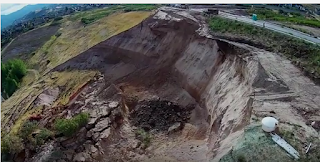
 August 5, 2014 around 6:00 a.m., after a few days of heavy rains, the slope above Parkway drive in North Salt Lake City Utah, gave way creating a landslide that pushed one house off of its foundation and took over part of a tennis court. Residents had reported, for many months leading up to the slide, the earth was starting to move and creating cracks.  The slide created a 60-foot-high main scarp above the landslide mass.  The landslide was  about 500 feet wide and 500 feet long.


This slope was destined to fail from the beginning.  In the 1990's this was the site of gavel quarry and when the property was excavated for development the slope was steepened. After the slide, geologists determined that the site has volcanic deposits that turn to clay when repeatedly exposed to water.  They also noticed fine-grain sediments from just below the shoreline of the prehistoric Lake Bonneville. This combination is a recipe for a disaster. 

The remediation included regrading much of the slope to lower its overall steepness, and installation of a drainage system to collect water from the slope and transport it off the landslide to the local storm drain system.


Below is a link to live coverage of the slide captured by a local television station.
Live coverage of slide


Wednesday, June 14, 2017

Lesson 9: Anatomy of mid-Ocean ridges

Lesson 9: Anatomy of mid-Ocean ridges

Mid-Atlantic Ridge


The Mid-Atlantic Ridge is located in the Atlantic Ocean. It has a slow spreading rate of about 2.5 centimeters per year. Slow spreading ridges have steep sloping flanks and the topography is rugged.  Fast moving ridges have gentler slopes and a smoother surface and can move more than 9 centimeters per year.


Another characteristic of this ridge is how old the crust gets the father away you get from the center. In ridges that have a fast moving rate, the crust on the outer edges may only be 3 million years old.

Wednesday, June 7, 2017

Lesson 8: Earthquakes

Earthquakes in Utah


Below is a map of Earthquakes in Utah over the past 2 weeks.  As you can see there's less than 30 hits.  The table next to the map shows the magnitude and the depth of the quake.  All the quakes in Utah over the past 2 weeks have been less than 2.0 magnitude and on average more than 3 miles deep.


After seeing the Earthquakes for just 2 weeks I was interested in what 1 year would look like.  The picture below shows all the hits for 1 year (June 5, 2017 - June 5, 2016), 933 earthquakes. I researched back a few years and noticed on average about 1,000 Earthquakes per year.   Again all the hits were less than 2.5 magnitude.  I wasn't too surprised by the number of earthquakes.  However, I was surprised at how small they are. This makes me wonder if having a lot of little quakes keeps the big one from happening, or if the tiny quakes are priming the pump, and setting the stage for the big earthquake that is predicted for the area?


 Since we read about liquefaction in our reading, I thought it would be fun to add this map showing the liquefaction of the Salt Lake Valley.  At first I was a little surprised that the eastern side of the valley shows a very low potential.  The soil on that side is very sandy, but also elevated, so this would keep it from having the water it needs for liquefaction. 
 Finally, the map below is of the Western United States.  The one thing that caught me off guard when I was looking at all of the earthquake hits in the United States is the cluster in the Oklahoma area.  I would be nervous living that area.  With very few faults, what would be creating so many earthquakes in that area?


Tuesday, May 30, 2017

Lesson 7: Science VS Religion

Lesson 7: Science VS Religion


The same laws of Godly time do not always coincide with those of the physical world.  Scientist see how things have happened and then try to find a reason to make them fit. I usually recognize science as an educated guess.  The scientists will change theories on how things work, but God's law is the same today, tomorrow and forever.

With the Gospel we are to remember that everything happens in order.
I think that when we look at the time line of the Earth from the science viewpoint, we can compare it and see the similarities to the creation that we read about in the scriptures.


In the book we read about the "Goldilocks Scenario".  Where everything had to be just right.  The creation of the Earth and Solar System did not happen by chance, it was thoughtfully considered and planned out from beginning to end. God does not make mistakes, and he created a very beautiful place for us to live while we travel through brief moment in time.


Lesson 13 Climate Change

Lesson 13 Climate Change  Utah is warming at twice the global rate and is seeing more record setting rainfalls and a lower amounts of...